


–
It’s been 20 years since the U.S. Air Force did the world a solid by granting full access to the Global Positioning System. In that time, motorists have moved from crude, monochrome line maps to 3-D topographic displays rendered with skies, buildings, and live traffic information. But even after the Defense Department agreed to stop scrambling civilian signals in 2000, GPS isn’t accurate enough for the next generation of drivers who won’t drive their cars at all. And all those assists that allow hands-free operation for a few amusing seconds also could use better information.
–
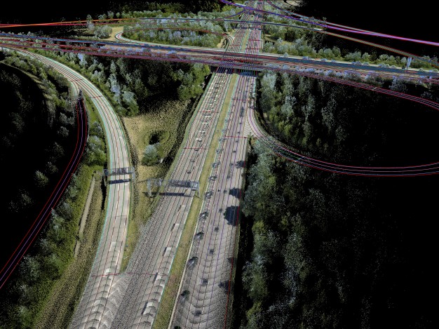
High-definition mapping is the core of tomorrow’s autonomous cars. Radar, LIDAR, and visual cameras are only feelers to a car’s immediate vicinity. Picture an ant crawling through grass, navigating blade by blade. HD maps would render every last strand of the entire lawn—and locate that hard, black surface where those giant wheeled death machines prey on tiny insects. Whereas a regular map can position a car’s location to within a meter, HD maps can do it to within as few as 10 centimeters. It’s why Audi, BMW, and Daimler purchased a Nokia spinoff, called Here, for $ 3.1 billion in August. The deal grants them navigation software to power their next autonomous prototypes and, once the lawyers sort it out, the real things.
–
“It started from us looking at how to move from representing the standard navigation map to how you present reality in 3-D,” said Here senior vice president Vladimir Zhukov. “You need another order of magnitude in the precision.”
–
–
Here—which ended up being Nokia’s only worthwhile enterprise after it blew off the iPhone and saw its business in mobile phones collapse—has regular mapping software installed in four of every five cars built with a navigation system (it purchased Navteq in 2007). The company has been gathering HD data for the past five years and has racked up more miles than any of its competitors.
–
Over the summer, TomTom announced a new partnership with Bosch, which creates many of the current driver-assist systems, to create HD maps. Uber purchased a California-based map company, deCarta, in March and is hatching a future of automated ride-sharing.
–
The three automakers could have signed up with Google, which boasts more than 1.2 million miles in its self-driving (but not driverless) Toyotas, or Apple, which has just begun its own autonomous quest. But Silicon Valley operates with a volatile secrecy. Aggressive tech firms do not behave like Tier 1 suppliers, pandering to every last point on a carmaker’s checklist. Most are cool with Apple CarPlay and Android Auto taking over a minor portion of their cars. When we shift to full automation, software becomes the car.
–
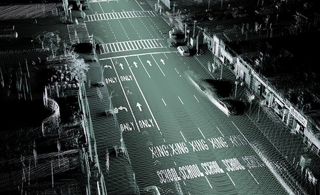
Google isn’t nearly as close as the media hype suggests. The company has only saved some 2000 miles. Here’s 400-car armada has mapped 1.8 million, and they’re on a feverish pace. One of their engineers in Chicago, Ken Liu, records 100,000 miles a year. To put this into perspective, rendering the average road requires 1.4 billion data points: the exact height of curbs, where lane markings fade, sewer grates, barriers, and every physical observation we memorize on our daily routes.
–
–
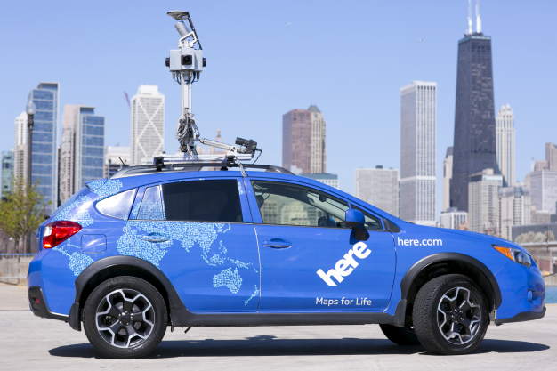
Like Google’s worldwide fleet of freaky camera cars, Here captures the streets one block at a time. They mount similar equipment several feet off the roof: Four wide-angle 24-megapixel cameras within a sphere enclosure, spinning LIDAR cameras scanning 700,000 points on every object within a 300-foot radius, gyros for pitch calculation, and of course, GPS. A 50-pound box in the passenger footwell wires them all to a 1-terabyte hard drive, a tablet running diagnostic software, and a 12-volt car battery to power the entire setup. Here’s technology, minus the space probe on the roof, powered the Mercedes S500 Intelligent Drive prototype that auto-piloted 62 miles through Germany.
–
“You really need a map when you’re trying to predict your behavior beyond the sensor of the car,” Zhukov said. “If you are just following the car ahead of you using assisted cruise control, usually you do it based on a sensor. If you want to have assisted cruise control at high speeds, when you lose the car around a curve, you actually need to know there is a curve, and that the car didn’t just disappear.”
–
Later this year, Here will integrate HD mapping for the first time on a normal production car (figure it’ll be something German and expensive). Essentially, these owners will become beta testers without knowing it. Raw 1s and 0s from the sensors and cameras in thousands of cars will let Here verify the accuracy of its maps. With every tweak it makes, the company can push out cloud updates over a 4G cellular connection so every car receives the latest maps.
–
“It becomes sort of a self-learning system. The more cars that are using this, the more feedback we get, the more automated our processes become, the faster we can incorporate those changes,” Zhukov said.
–
–
- –
- Don’t Tear Up Your License Just Yet: Why Autonomous Driving Still Is a Ways Off
- We Go for a Ride in Google’s Self-Driving Car
- Here’s What Google’s Self-Driving Car Sees When You Crash into It
–
–
–
–
–
HD maps have already been used in limited cases. BMW’s 2011 3-series Track Trainer and Audi’s 2014 RS7 Piloted Drive Concept relied on HD maps of Laguna Seca, Hockenheim, and other racetracks so they could perfectly carve corners. Additionally, Delphi completed a coast-to-coast automated drive this winter without relying on stored HD maps. But what happens when an autonomous car’s sensors are blocked by fog, dirt, mud, ice, or snow? What happens if they’re damaged by debris? When we give up all control, an onboard HD map of our everyday world—the underlying Braille by which self-driving cars can fall back upon—may be the last reassurance that our vehicles know exactly where they’re taking us.
–